The Grenada National Water Information System (NWIS)
In collaboration with the CARIWIN project, the Government of Grenada launched its National Water Information System (NWIS) in January 2009, as a tool to address the problems of compartmentalized data, lack of central storage, and limited access to data for decision-making in the country. The NWIS is a powerful quantitative and qualitative tool to contribute to the strengthening of Integrated Water Resources Management (IWRM) in the Caribbean. It has now become the official repository for all hydrologic, climate, land, watershed, infrastructure and water-related data in Grenada. The NWIS allows not only the archiving of data, but also displays the information in a very comprehensive and visual manner to give a snapshot of the water resources at any time and geographical scale. It was developed through a collaborative process engaging data collectors, data users and stakeholders throughout the development of the system and significantly expanded on the capabilities of earlier Water Information Systems through (i) the introduction of a user-friendly system administration interface that readily facilitates the inclusion of new parameters into the database and (ii) links to Google Earth imagery. The Grenada NWIS portal can be accessed at http://cariwin.gd.
The NWIS is a tool that can provide timely information in a format both understandable and convenient for decision-makers and planners as well as the public, and, if used to its potential, that can drastically improve their ability to address water resources and land use challenges in the country. On a regional scale, the Grenada NWIS offers a starting point for the modernization and standardization of data management led by CIMH. As part of its role in maintaining a central archive of meteorological and hydrological data for its member countries, CIMH is seeking to expand on the Grenada system to develop similar systems in remaining CIMH member countries.
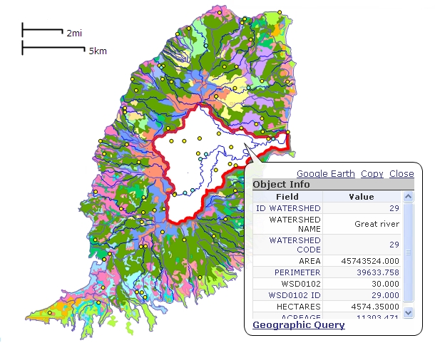
Snapshot from the Grenada National Water Information System
Displaying the Great River Watershed against a land use backdrop
Related publications:
National Water Information Systems: A Tool to Support Integrated Water Resources Management in the Caribbean
Full paper to be presented at the 5th Caribbean Environmental Forum in Jamaica, June 21-25, 2010


